Rover Location Database
United States Rover Locations
- USA
- USA List
- BO Alaska
- BP Alaska
- CM California
- CN Pacific NW
- CO Canada
- DL Mexico
- DM Southwest
- DN Rockies
- DO Canada
- EL Texas Florida
- EM South
- EN Central
- EO Canada
- FM East Coast
- FN Northeast
- FO Canada
- Select Grid
- Data Check
- Add a Place
Grid Square DM66
4 locations - Heron Lake - Lybrook Mesa - Angel Peak Overlook - Brazos Summit
Potential VHF rover sites in grid DM66.
DM66 dimensions are 111.2 by 69.2 miles.
Explore this grid in Google Earth or equivalent:
Heron Lake, DM66qq06
| Latitude, Longitude |
|---|
| 36.692212, -106.660333 |
In the middle of beatiful Chama Valley, on top of a hill, with good sight lines in all directions (except NW). Not quite as good as the Brazos Summit.
This is the Blanco electric campground, where the best spots for VHF are #24 and #26. Bathroom and showers nearby. Includes electrical hookup.
Book ahead in summer, as it's popular with long-term RVers.
In 2022, the camp host Bryan was next door, who was very friendly and supportive. Call ahead or bring gas; there were very few restaurants in Chama open in 2022.
Restrictions:
This campground can only be reserved using the official reservation system of the New Mexico State Parks. $14 plus reservation fee. Even if you drop in and find available spots, you must call (or use the web portal) to reserve your spot.
Bring a Verizon phone; T-Mobile worked okay at #26. Fires not permitted in summer of 2022, and that may be standard in summers in this arid climate.
Lybrook Mesa, DM66ff20
| Latitude, Longitude |
|---|
| 36.210442, -107.563846 |
One of these sites forms a broad flat area with good site lines in all directions. This operating site is in Sandoval County but the cell tower is in Rio Ariba County.
I've operated there twice and was able to reach stations in Albuquerque on all bands 50 through 1296 with good signal strength. Distance is about 95 miles on a bearing of 145 degrees true. This is a good 6 meter site when the band is open. It's very quiet.
Driving directions:
- Turn south off US Hwy 550 on an unnamed dirt road that rises abruptly off the Hwy 550 surface then crosses a cattle guard at a fenceline that parallels Hwy 550.
- A cell phone tower is visible south of Hwy 550 when approaching from the north or south.
- Passing an oil production site on the left, the road deteriorates and climbs toward the cell tower but is easily passable in good conditions.
- Just before reaching the cell tower, bear right on a smaller road which leads to a narrow mesa with more oil and gas sites.
Restrictions: A high clearance vehicle is recommended but not required in good road conditions. The access road is not recommended in rain or snow. In 2015, the road surface was dirt with spots of gravel.
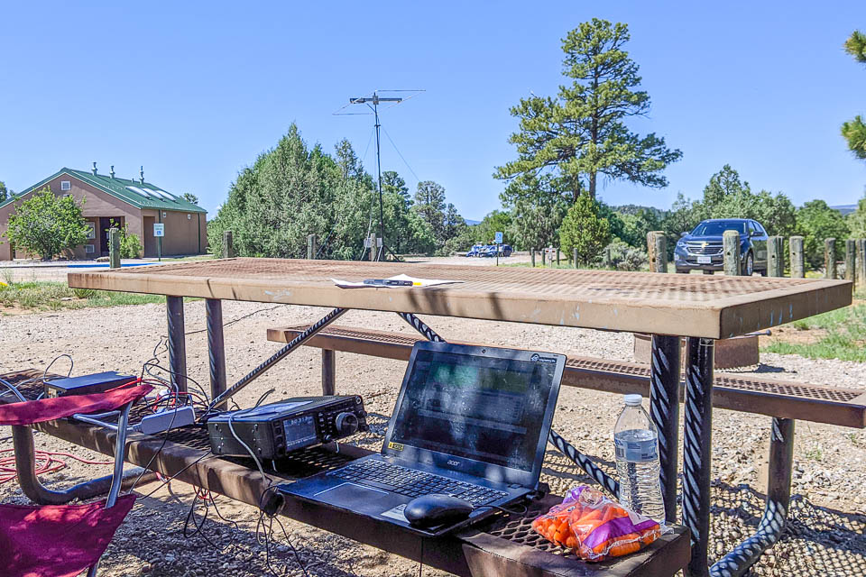
Angel Peak Overlook, DM66am85
| Latitude, Longitude |
|---|
| 36.522870, -107.931880 |
The terrain to the north, west and east drops several hundred feet into the badlands. Terrain to the south is flat.
I've operated there 3 times and each time I found I could reach most of Colorado except Denver which is in the "Rocky Mountain Shadow". Most of Western Colorado some of eastern Utah and most of northwestern New Mexico is reachable on frequencies from 50 through 432. Signal reports from DM58 stations while operating there are unusually strong.
Driving directions:
- From US 550 turn east on NM State Road 7175 at the sign identifying the Angel Peak Recreation Area.
- The road surface is gravel and easily passable with any vehicle having moderate ground clearance.
- Drive east through the "Land Farm" about one mile.
- Look for a curve to the south and two covered picnic tables.
- The site is near the picnic tables at the Badlands Overlook.
Brazos Summit, DM66tq65
| Latitude, Longitude |
|---|
| 36.691493, -106.361806 |
| < Previous | Page 19 of 21 | Next > |
©1998-2024 Barry Hansen