
Rover Location Database
Washington Rover Locations
- WA Map
- WA List
- Select Grid
- WA from CN87
- Rare WA Grids
- WA Counties
- CN76 Long Beach
- CN77 Forks
- CN78 Sekiu
- CN85 Portland
- CN86 Centralia
- CN87 Seattle
- CN88 Belling'm
- CN95 The Dalles
- CN96 Yakima
- CN97 Mt Rainier
- CN98 Mt Baker
- DN05 Pendleton
- DN06 Tri-Cities
- DN07 Moses Lk
- DN08 Okanogan
- DN16 Pullman
- DN17 Spokane
- DN18 Colville
- Add a Place
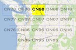
Grid Square CN98
15 locations - Big Hill - Hart's Pass - Sauk Mtn Trailhead - Fox Peak - Cooper Mtn - Long Creek Rd - Lime Kiln Trailhead - Mountain Way ES - Darrington - Darrington2 - Mt Pilchuck Trailhead - Mt Pilchuck Landing - Green Mtn - Slate Peak - Granite Falls HS
Potential VHF rover sites in Washington grid CN98.
CN98 dimensions are 91.6 by 69.2 miles.
Explore this grid in Google Earth or equivalent:
Big Hill, CN98sa03
| 48.015947, -120.492546 |
Here's another high spot near Lake Chelan. It needs scouting for VHF.
Big Hill is a trailhead + primitive campsite on the west side of Lake Chelan about 13 miles west and a little south of Fox Peak. Big Hill is in grid CN98sa while Fox Peak is in CN98vc. The drive may be up to an hour shorter from Seattle than the drive to Fox Peak.
I have never actually been to Big Hill but I’ve hiked in the general area a number of times. Big Hill is supposed to be really impressive in late September when the Larch trees turn golden.
USFS information: www.fs.usda.gov/recarea/okawen/recarea/?recid=81243
Tom KJ7BXA
Driving directions: From Entiat, WA travel south on US-97A for 1.2 miles.
Turn right (west) on Hwy 19 (Entiat River Road) and continue for 28.5 miles.
Then turn right on Forest Road 5900 (Shady Pass Road) and stay on 5900 for about 8 miles.
Turn left on Forest Spur Road 112 and travel about 3 miles to the end of road.
Restrictions: Big Hill is at 6800 ft so it may take longer to melt out than Fox Peak.
Hart's Pass, CN98pr93
| 48.720834, -120.670139 |
Highest road in Washington State. This spot is a campground that gives access to the Pacific Coast Trail.
It's ideal for a few days of camping and hiking with amazing amazing stars at night. There's even a concrete pad for your small telescope setup.
Restrictions: The road is quite rough and you may see lots of other cars with blowouts.
Sauk Mtn Trailhead, CN98em75
| 48.521341, -121.607530 |
Sauk Mountain trailhead is along Hwy 20 just North of Rockport, and on the way to Winthrop, WA. It has a good view and nice roads and a big parking lot. Map views hint at a pit toilet in a tiny A-frame outhouse about 50' up the hiking trail.
You can hike the trail to the top for more excellent views. Maybe a light weight, 10Ghz backpack station would be fun to take along.
Fox Peak, CN98vc21
| 48.088932, -120.228847 |
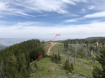
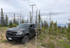

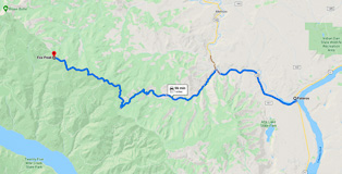
Fox Peak is a little further along on Cooper Mtn Road, about 10 miles NW of Cooper Mtn. It offers a nice clearing with good horizons in most directions.
Needs more scouting.
Driving directions: The preferred route from Pateros is less precarious and in better condition than
from Cooper Gulch and the city of Chelan.
- Make your way to Pateros on Hwy 97
- Turn west at Pateros onto Methow Valley Hwy 153
- Turn south onto Black Canyon Creek road
- Stay on this road as it becomes Forest Service 4010
- Continue upward on NF-4010 until the tee intersection where you
turn right onto Cooper Mtn Road NF-3107
- Continue on Cooper Mtn ridge until you reach Fox Peak
Cooper Mtn, CN98wa92
| 48.011291, -120.083787 |
Cooper Mtn and Cooper Ridge are high above Lake Chelan on its east side, well above Echo Valley Ski Area. Satellite images suggest forest service roads to the topmost peak. No radio towers. Open horizon in all directions. Needs scouting.
This is very remote area, estimated over an hour from the city of Chelan, a popular resort and "second home" town.
Long Creek Rd, CN98tq40
| 48.667800, -120.379654 |
Long Creek Rd is an open spot near the eastern edge of CN98 on the side of Goat Mtn. Needs scouting. It's included here in case you're passing through on Hwy 20 and want a hilltop in CN98.
This appears to have good horizon in all directions except blocked toward NW. No campsite nearby.
Lime Kiln Trailhead, CN98ab88
| 48.077457, -121.932600 |
This spot is a gravel parking lot for the Lime Kiln Trail.
Fair propagation to the North West, West and South. This spot works better than nearby Mountain Way Elementary School, probably because it is 200' higher. I first used this spot in the Jan 2013 contest.
During good weather it may be difficult to find an open and level spot due to crowding. It seems to be a very popular hiking spot. I visited this spot briefly in 2011, but the level parts of the parking lot were filled with cars. So, I went to nearby Mountain Way Elementary instead.
Driving directions: Google Maps's directions to Lime Kiln Trailhead are clear and easy to follow.
Restrictions: This is a Snohomish County park. No permit is required. Hours may be limited.
Mountain Way ES, CN98ac31
| 48.088787, -121.970120 |
WW7D: I've worked from the Mountain Way Elementary School parking lot a number of times, and it works fairly well. It's at 400'--a little higher than the high school. In JanVHFTest, I spent 1.5 hours there and got (10) 6m, (16) 2m, (2) 1.25cm and (6) 70cm QSOs. In JunVHFTest, I spent a little over 30 minutes in the grid and had (10) 6m, (8) 2m, (2) 1.25m and (4) 70cm QSOs. There are definitely some blind spots from the location. I've always worked out of the north parking lot (not sure why); the south lot may work better. Location: 48.088871, -121.969944
Darrington, CN98fg84
| 48.268481, -121.510834 |
There is a ridge up in the hills high above Darrington with an open exposure east but disappointing propagation in all directions. It's not quite high enough that your signals will clear nearby ridges. Maybe it'd work okay with meteor scatter but otherwise don't bother with this spot.
The drive up here is on good roads and spectacular Pacific Northwest surroundings. This has got to be one of the most enjoyable mountain drives I've ever driven.
Restrictions: Snow is likely to last into July.
Darrington2, CN98gj61
| 48.380874, -121.448487 |
Up in the hills above Darrington are some promising unpaved roads on mountains. This spot is a trailhead parking area with open horizon in all directions except NW.
Needs scouting.
Restrictions: Good 4WD is required for steep roads.
Mt Pilchuck Trailhead, CN98cb27
| 48.071081, -121.813781 |
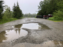
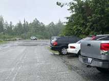
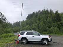
This site is pretty bad. It's a large parking lot for a trailhead near the top of Mt Pilchuck. The road has extremely bad potholes in 2020 and it's very slow going, but 2WD sedans drive it all of the time. It's a popular destination for hikers; expect a lot of traffic.
Wooded and hilly area. Good horizon to N and NW. Practically no exposure any other directions. I recommend against this spot; it's really hard on your vehicle for no good horizon anywhere.
Has a vault toilet and Verizon had two bars signal.
Driving directions: Through Granite Falls on Stanley Street
- Go east on Mountain Loop Highway
- Drive approximately 11 miles to Verlot and then cross a big steel bridge
- Just past bridge, look for "Mt Pilchuck" access sign and turn right
- Follow main forest road 6 miles to turnoff to the parking lot
- http://www.topozone.com/map.asp?z=10&n=5323190&e=589544
Mt Pilchuck Landing, CN98bb96
| 48.069167, -121.838056 |
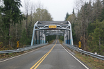
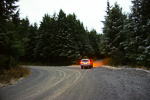
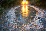
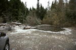
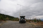
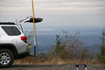
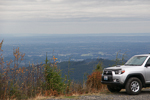
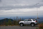
Logging landing on west side of mountain. Excellent exposure to N, S, and W. Blocked on East by the remainder of Mt Pilchuck. This is a premier operating location with excellent paths to the north, west, and south. 15 miles east of Granite Falls.
It would be very rough for low slung autos to make it in since the ruts and low areas and rocky pools can be bad. Two-wheel drive pickups will have less problem.
There is ample room to camp and set up, though you can expect frequent traffic through the area.
10/2003 update. People have been burning pallet boards at the landing, and there is an incredible quantity of nails in the dirt on the uphill side of the road. These nails have been burned and are rusty, so they are hard to see. Look before you drive off the road, and check your spare tire before departure!
11/2012 update. This is still an outstanding location with line-of-sight access to most of Puget Sound, and magical ducting into Oregon. The trees are beginning to come back and are now about head height; it will be just a few more years until they start blocking microwave paths. Another good reason to bring saws and pruners.
Driving directions: Go through Granite Falls on Stanley Street.
- Go east on the Mountain Loop Highway.
- Watch your speed through the 35 mph zones in towns - police patrol this area regularly.
- Drive 12 miles to Verlot and the big steel bridge. The milepost is just past the bridge.
- Look for "Mt. Pilchuck" access sign on left just past bridge.
- Turn right up the hill here![]()
- At 1.4 miles is a gate here![]() If closed, try nearby Green Mountain instead.
If closed, try nearby Green Mountain instead.
- At 4.8 miles turn right off the main road here![]() No road marker but the maps say NF4240.
No road marker but the maps say NF4240.
- At 5.1 miles is a very big nasty puddle here![]() Walk it and clear obstacles, keep right.
Walk it and clear obstacles, keep right.
- At 5.5 miles turn right to go downhill here![]() The left goes through a gully by a rock, that's not the way.
The left goes through a gully by a rock, that's not the way.
- At 5.7 miles is the landing, park here![]()
Restrictions:
- Bring chain saw, shovel and pruners. Shrubs encroach and trees fall on the unmaintained side road.
- If you are flying rover antennas you should also bring a pole pruner.
- Turn your headlights on because of the narrow road and limited visibility.
- No cellphone service.
Green Mtn, CN98bd92
| 48.136900, -121.835300 |
This is a mountaintop north of Mt Pilchuck and ENE of Granite Falls.
Driving directions:
Take Hwy 92 east of Granite Falls, to Robe (a spot on the map at best). On the left will be two tall power poles with transformer platform, and one of them has a white fixed wireless vertical antenna. Turn left after these poles. There are two roads, one 90 degrees from Highway 92, the other veering off to the left. Take this road. It is paved up to a fork in the road. Take the right gravel road up the mountain. It will wind around, with some spurs you might be tempted to turn onto, do not. The main traveled road is the most worn, and in 2006 you would have to cross a slight gravel berm to leave the main road. The main road is not overgrown, and has plenty of clearance for antennas. The sides are likely overgrown, so you will know if you took a wrong turn.
At the 2900 ft level you will come upon a 90 degree turn to the east and will have a great view. This is the best stop and is the most western high spot on the mountain. There is room to turn around here and park on the side. It is far enough west of Mt Pilchuck to afford a clear shot of Mt Rainier and CN97 stations. No coverage to the east from here, just rock, so plan for that when the evening 6-meter openings come in the summer. It is about a 18 minute run, the road has been in very good shape, much better than Mt Pilchuck's road, and is quicker access and higher also. Lots of shooters come here to the lower elevations.
Going further takes you along the north side of the upper ridge for maybe 6 miles before you cross over to the south side of the saddle where it is very open view east, south, and west. North and NW will be obstructed, and Mt Pilchuck will obstruct the view straight south. CN97 stations are tough from here.
Restrictions: Take along a saw in case a tree falls across the road, you might be the first to deal with it.
Slate Peak, CN98pr87
| 48.741474, -120.680780 |
Forest Service Lookout west of Goat Peak lookout and northwest of Mazama off Highway 20.
This location is car drivable after July 4 most years to 7300 ft. The road to the lookout is gated, but it is a short hike to the station. This site was a radar site at one time. Radio Mobile shows that it should provide good signals to nearly every major population center as far south as Portland.
3/16/2009 update from K7CW. I researched getting permission to operate from Slate Peak for a June VHF contest a few years ago. The district ranger sounded amenable to letting us do it, but he referred me to the radio tech who maintains the repeaters. The tech told me that tests would have to be run to determine if there would be interference problems. He said that he doubted that permission would be granted. I took that as an indication to not bother him further.
Slate Peak is a pretty good location, except for the climb past the gate. But, if you can get them to give you a key, there is a lot of room at the top - enough to set up several stations.
The road to the summit is the highest public road in the State of Washington.
Driving directions: West of Goat peak lookout (7000ft) and NW of Mazama off Hwy 20.
Granite Falls HS, CN98ac10
| 48.087454, -121.985557 |
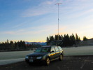
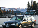
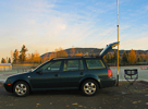
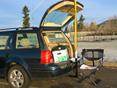

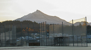
This is a relatively easy drive from home in order to activate CN98. The whole CN98 grid square is rather mountainous, containing Mt Baker and Mt Pilchuck, along with the rugged Cascades that extend unbroken into British Columbia.
The high school parking lot is in the valley so don't expect long-range propagation. It has a good take-off angle to Seattle, the Everett repeaters are loud, and it's close to northwest Washington. I only made two contacts (Ray W7GLF Kirkland, Paul WA9BTV Camano Island) and barely heard the Portland stations a few times.
Mt Pilchuck and Green Mountain are nearby and much better locations for radio work. However, do not enter these mountains in winter without 4-wheel drive and appropriate gear. Otherwise you may have to back down steep glare-ice one-lane roads and pray your ABS is functional going backwards. Don't ask me how I know.
| < Previous | Page 17 of 25 | Next > |
©1998-2026 Barry Hansen