Rover Location Database
Travel
- Travel
- Apr '25 DN07
- Nov '24 DN19-29
- April '23 CN76
- Sept '22 CN76
- May '22 CN93
- Feb '22 CN93
- Jan VHF '22
- Dec '21 CN78
- Aug '21 CN76
- July '21 CN78
- May '21 Ely, NV
- July '20 CN98
- June '20 DN08
- June '20 N7G
- July '19 DN27-07
- Sept '18 CN98
- June '18 DN08
- June '18 DN22-43
- June '18 EN02
- June '18 Article
- June '18 EM87
- Summer '17
- Sept '16 CN87
- Apr '14 CN82-92
- Mar '14 Plan
- Jan VHF '14
- Jan '13
- Oct '12
- May '12
- Jan VHF '12
- Sept '11
- June '11
- May '11
- April '11 CN97
- March '11 CN97
2017 Hilltop Ideas
This is a collection of notes about plans, ideas and places that look interesting.
Grid Exploration Award for Washington State
The PNW VHF S offers an award to work or activate all grids with land mass in the Pacific Northwest. Rules here. Some of the incremental awards along the way:
- Apple - work all grids in WA using any combination of bands
- Capt Lewis - activate all grides in WA using any combination of bands
- Explorer - activate all grids in WA using a single band (my favorite)
There are 18 grids in Washington state: CN76-77-78, CN85-86-87-88, CN95-96-97-98, DN05-06-07-08, DN16-17-18
Here are some routes that might sensibly cover the state in a four one-day trips:
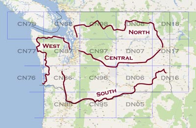
- South: Drive west from Pullman through Tri-Cities and follow Columbia River to Portland
Route of 450 mi, 8 hours
(DN16, DN06, CN95, CN85, CN86)
- West: Camp on Long Beach, then north around Olympic Peninsula
(CN76, CN77, CN78, CN88)
- North: Drive east from Darrington through Okanogan, Republic and Kettle Falls, ending in Spokane
(CN88, CN98, DN08, DN18)
- Central: Drive west from Spokane along I-90 to Seattle
(DN17, DN07, CN97, CN87)
Haystack Butte, Goldendale, WA CN95nq
Lat 45.703564, -120.854954, Alt 2200'
Dist from home: 210 mi, 3h 40m,
driving directions via Yakima
A hilltop site directly north of the Biggs Junction Columbia River Bridge on the WA side. It's an old AT&T microwave site on the bluff overlooking the river, with a great view to the south and east.
Rye Grass Rest Area, Vantage, CN96vw
Lat 46.932975, Long -120.185709, Alt 2500'
Dist from home to eastbound rest area:
113 mi, 2h 0m, WB driving directions
Dist from home to westbound rest area: 135 mi, 2h 20m, EB driving directions
A small rest stop along I-90 in a lovely wind swept area with rest rooms, wifi and a view. On a clear day, Mt Rainier (CN96dv) can be seen 70 miles away due west through a gap in the hills.
Be aware it's a popular and busy area, so you may be interrupted with comments and questions. Recommended to have signage to inform passersby and avoid alarming anyone.
Lion Rock, Ellensburg, CN97rg
Lat 47.24081, Long -120.58165, Alt 6300'
Dist from home: 108 mi, 2h 24m drive, driving directions
A popular spot for VHF operating.
Badger Mt Ski Area, Wenatchee/Waterville, CN97vo
Lat 47.58492, Long -120.17301, Alt 3500'
Dist from home: 155 mi, 3h 9min drive,
driving directions
Recommended by a ham in Wenatchee. The ski hill top is located at an elevation of 3,500 feet about 700 feet down from the top of Badger Mt. on the east slope, so there's no VHF path to the west with all of Seattle's VHF activity. But it's easy to reach from Wenatchee and has good path to Spokane and Coeur d'Alene.
Suntop Lookout, Mt Rainier, CN97eb
Lat 47.041389, Long -121.593611, Alt. 5,270'
Dist from home:
63 mi, 2h 20min drive, driving directions
In the Mt Rainier National Park is a lofty lookout long used for forest fire spotting. It is now manned by volunteers and you can drive almost to the top at the 4500' level.
Providence Pt, Issaquah, CN87xn54 (canceled)
Lat 47.560919, Long -122.039008, Alt 600'
Dist from home: 4.2 mi/12 min drive, 1.5 mi SE
I explored this area and found no good operating location among the heavily developed retirement community.
CN86-87-96-97, Carbonado, Washington (hmmm)
Lat 47.00000, Long -122.00000, Alt 1,600'
Dist from home: 62.9 mi/88 min drive, 40.3 mi S
I wonder if there are enough roads in this area near Mt Rainier to support grid square circling?
One report shows hams camped on Poch Peak south of Carbonado for the June 2004 VHF contest.
Steptoe Butte, DN17ia (wishful thinking)
See KF7CN on Steptoe Butte DN17ia for the September 2004 VHF Contest. There are lots of microwave dishes but the geography is ideal.
Squak Mtn State Park, CN87xm40 (planned)
Lat 47.503982, Long -122.04742, Alt 2,000'
Dist from home: 12.1 mi/28 min drive, 5.5 miles due S
Squak Mountain is the middle of the chain of Cougar - Squak - Tiger mountains marching east from Bellevue. These are wondefully tall peaks visible for many miles around.
This might be primitive forested national park area. Although google maps shows roads, I suspect it is accessible only by 4-wheel drive vehicles. Local reports say it's usually gated 100 yards in, and a really nice hike to the top in summer.
| < Previous | Page 23 of 36 | Next > |
©1998-2026 Barry Hansen