
Rover Location Database
United States Rover Locations
- Select Grid
- USA
- USA List
- BO Alaska
- BP Alaska
- CM California
- CN Pacific NW
- CO Canada
- DL Mexico
- DM Southwest
- DN Rockies
- DO Canada
- EL Texas Florida
- EM South
- EN Central
- EO Canada
- FM East Coast
- FN Northeast
- FO Canada
- Data Check
Grid Field DL
16 locations - Christmas Mtn - Dryden - Ranch to Market Rd - Hwy 169 Near Grid Corner - Talley-2 - Chinati Natural Area - DL79-DM70 Grid Line - DL79-DL89 Grid Line - Rancherias - Papalotito Colorado - Yedra 2 - La Mota 2 - Faver Ranch Road - DL88-DL89 Line - Sotol Vista Overlook - Hwy 99
Potential VHF rover sites in grid DL.
DL dimensions are 2111.8 by 1623.5 miles.
Christmas Mtn, DL89hk16
| 29.444283, -103.405460 |
Bare Bones Campground offers a good base camp to find a better hilltop spot on Christmas Mountain.
Dryden, DL89xx74
| 29.979000, -102.021050 |
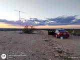
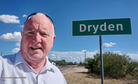

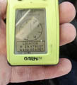
This is a local high spot in the northeast corner of DL89, right off of Hwy 90. My parking spot was 100 feet off Hwy 90 and about 12 feet above it.
First, it's most likely you didn't work me in DL89 in July 2024. Conditions stunk. Only two leaders made it into the log.
The side road is rocky -- if you have low riding auto, this is not the place for you. I took the family car and kept the tires on the high ground. It was difficult to get stakes in the ground and I was happy took a short 16-foot high mast. Future trips may set up little further north and closer to where land elevation decreased.
There is fair amount of traffic on Hwy 90. I saw several DPS, Border patrol vechicles and 18-wheelers on Hwy 90, compared to almost no traffic north of Dryden. If you drive the road between Dryden and Sheffield you'll understand why you don't see 18-wheelers on that road! What a roller coaster.
This was my family car going on a Rover mission (technically, The Boss says it's hers) chosen partly to test how to pack so I can operate 50 Mhz on family trips. A bigger antenna doesn't fit, so The Moxon is the antenna of choice for trips this vehicle. Gasoline cost for the trip was way less than the truck and the car is fairly RF quiet while supplying AC. The rig operates from a 100 Ah battery, not the car battery.
I shut down about 9PM, and by midnight I was eating Whataburger on the south side of Midland. The distance makes this about furthest away I'll operate for a day trip from my QTH.
Read more W5AJ adventures at w5aj.eqth.net
Driving directions: One picture shows a ground view, entrance to site is seen just to right/east. The site is further up at highest area of side road
Restrictions: Don't expect to buy gasoline in Dryden. Not much of anything there.
Ranch to Market Rd, DL79xx75
| 29.980079, -104.021550 |
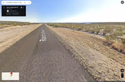
This is a local high spot slightly south of the DL79-DM70 grid line with a nice wide area alongside the road. Park between the road and the fence.
As is typical for locations that are far south in West TX, you need good Es. We don't recommend going unless you expect GOOD Es.
Fair Cell phone service. No power lines, noise ran S0 to S1 (band noise?). The grass had been mowed. This is out of the way, only two SUVs went by during the morning I was there.
Driving directions: Drive south out of Marfa TX, in a few miles turn left and go south on Hwy 169, continue into DL79.
Restrictions: Don't park near the Red Ant bed.
Hwy 169 Near Grid Corner, DL79xx75
| 29.979340, -104.022222 |
Talley-2, DL88jx78
| 28.993863, -103.186340 |
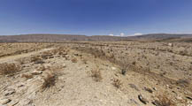
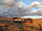
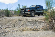
Talley-2 is the most favored campsite in Big Bend National Park to activate DL88.
It is 0.19 miles south of the DL88-89 grid line.
There are also Talley-3 and Talley-4 but they are lower and deep in a mesquite thicket along the river at the end of the 6-mile long Talley Road. The last mile of the Talley Road (approaching the Rio Grande) is especially rough and mesquite will scratch the hell out of your side panels.
| Weather forecast: | National Weather Service |
| Temps, wind, T-storms: | Ventusky |
| 3D panorama: | World Panorama |
DL88 activations include:
- Dec 2022 John NA6L
- Oct 2022 Dave KG5CCI
- June 2012 Marshall K5QE and Danny N5OMG
- May 2011 Dave NJ0W
In addition to restrictions listed below, we recommend:
- Recommend buying a "Back Country Road Guide" for $4.95 from the Park website.
- Recommend bringing traction boards (like MaxxTrax) for self-recovery.
- Recommend a sat phone for emergencies. There is no cellphone service.
- Recommend StarLink for internet access.
Driving directions: Check in with rangers at the Panther Junction Visitor Center. Ask about the current best route, because it changes with conditions. They will usually have you avoid Elephant Tusk because it's a very bad road.
Expect in-park travel time to be 2.5 to 4.5 hours depending on conditions and your driving speed.
Restrictions: Big Bend has different rules for different types of camping:
- Primitive Roadside Camping – no reservations, in-person check-in at Ranger Desk. There are sixty-four sites: 23 of the most popular can be booked in advance, 41 are booked only "day of" and includes River Road. (This is Talley-2)
- Wilderness Camps – can book up to 180 days in advance (get a backup reservation)
- Back Country Camps – this is for backpackers, not for Talley-2.
- No campfires
- No generators
- You can run your engine to recharge batteries. Limited to 15 minutes at a time.
- Pack out all toilet paper
- Maximum 2 vehicles, 8 people, no trailers
- After rainfall, River Road and Talley Road are muddy and may be impassable to all vehicles.
- A "high clearance 4WD vehicle" which is an SUV or truck type vehicle, with at least 15 inch tire rims or more, with a low gear transfer case, designed for heavier type use than a standard passenger vehicle, with at least 8 inches of clearance or more from the lowest point of the frame, suspension, or differential, to the ground, and including a means to power both front and rear wheels at the same time.
Chinati Natural Area, DL79sx38
| 29.993270, -104.474008 |
A modest ridge line might have a wide spot for camping in the Chinati Mountains Natural Area.
DL79-DM70 Grid Line, DL79wx29
| 29.999900, -104.142303 |
Remote back country unpaved road.
DL79-DL89 Grid Line, DL79xl95
| 29.482214, -104.000016 |
Big Bend State Park Main Road has a wide spot here on the eastern edge of DL79.
Rancherias, DL79xj98
| 29.412207, -104.000100 |
A dry campsite on the grid line DL79-DL89 in Big Bend Ranch State Park.
Papalotito Colorado, DL79xl87
| 29.489482, -104.016075 |
Yedra 2, DL79xm61
| 29.506466, -104.027994 |
La Mota 2, DL89am36
| 29.527125, -103.969196 |
Dry campground, no services, in the Big Bend Ranch State Park.
Faver Ranch Road, DL79uv61
| 29.882270, -104.276160 |
Wide spot on a slight hill right on E Hwy 67.
DL88-DL89 Line, DL88jx79
| 28.999983, -103.190915 |
Sotol Vista Overlook, DL89hf41
| 29.214563, -103.376631 |
Hwy 99, DL99xf18
| 29.241667, -100.068403 |
| < Previous | Page 9 of 20 | Next > |
©1998-2026 Barry Hansen